Village changes and the saga of the public toilets


Hodgson, in his History of Northumberland, says: “The village of Cresswell lies east and west, upon a slope, fronting the sea, is well built, and tenanted chiefly by fishermen.”
It takes its name, he says, “from a spring of fresh water at the east end of the village, the strand of which is grown up with water-cresses”.
Advertisement
Hide AdAdvertisement
Hide AdThis seems clear enough, until you realise that the village has changed since then.
The first map to show Cresswell in any detail is Armstrong’s map of 1769.
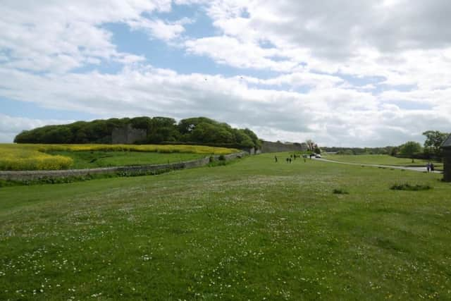
Lieut Armstrong was a painstaking and careful surveyor. In his map, Cresswell is shown as a large village. The houses cluster round the east side of the Tower, reaching out for short distances to the north, south and east. The rest of the village, as it is now, wasn’t there.
It’s possible that Armstrong got the layout of the roads slightly wrong. But it is clear that Cresswell in the mid-18th century was roughly where the green patch is, in our picture of the Links, in the field of oilseed rape.
Advertisement
Hide AdAdvertisement
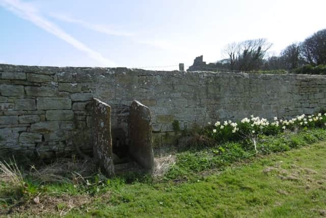
Hide AdThere is a pant in the field-wall below the Tower, two large slabs of stone projecting from the wall to form a protected bucket stand. I’m assuming that this pant was fed by a natural spring. If so, it may well mark the position of the well from which Cresswell took its name. And even if not, the original cress-lined spring can’t have been far away.
Even as Hodgson wrote, the village was already changing. Greenwood’s map of 1828 still shows the old village below the Tower, but the present layout was there as well, with Fisher Row along the shore, and a short row to its north, including the Crow’s Nest.
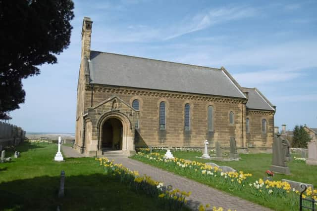
Meanwhile, at the top of the Links, St Bartholomew’s Church was built in 1836. It stands on the north side, beside some estate cottages and a school, which has two storeys and a carving of a globe on its finial. Opposite, in the grounds of Cresswell Hall, were the lodge and other cottages, and yet others more scattered. These are all now private residences.
The two ends of the village became linked in the 1970s with the building of modern houses in between.
Advertisement
Hide AdAdvertisement
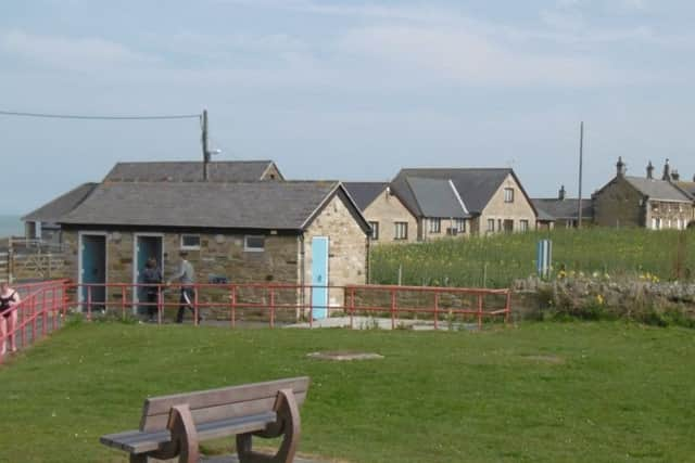
Hide AdAt the lower end of the Links is a flower bed set in a boat. The building on the right is the Crow’s Nest. This is also where the bus stop and the toilets are. And thereby hangs a tale.
When the Public Health Committee of Morpeth RDC met on August 2, 1949: “The Clerk read a petition from...the Parish of Cresswell, protesting against the siting of the existing temporary convenience, and of the proposed permanent building, on land adjacent to the village green.”
Coun Lane reported that there was to be a parish meeting on the subject, and asked for guidance. Very reasonably, the committee agreed that if the site was not acceptable, the meeting be asked to recommend another one.
Despite this, the plan to build the new ones went ahead regardless. Three tenders were received. The committee accepted the lowest, and resolved to submit the plans to the Ministry of Health for approval.
Advertisement
Hide AdAdvertisement
Hide AdIn August, however, the engineer and surveyor reported a letter from Cresswell Parish Council. The parish meeting did not like the proposed site, and suggested a new one. The committee, again very reasonably, resolved that the new site be approved.
All went well. In October the engineer reported that the county planning officer had approved the new site. It was owned by Carse and Son, of Amble, and he had written asking them for their observations. Messrs Carse duly replied. They did not like it — “the proposed erection would completely ruin the area for any other purpose”. The committee agreed to send a copy of the letter to the parish council for its observations.
On December 20, the engineer reported that the parish council had chosen a new site, and he had sent a plan of it to the county council. The minutes don’t say so, but this was evidently a third site. Either way, the planning officer approved it promptly and in time for the committee’s meeting in January 1950.
On March 14, however, a letter was received from Mr G. Paddudi and others, “protesting against the council’s proposal to erect a public convenience on land adjacent to his premises at Cresswell”.
Advertisement
Hide AdAdvertisement
Hide AdPerhaps rather wearily, Coun Lane agreed to take it back to the parish council, and it wrote on April 11 recommending “Site No. 1 at the corner of Pele Tower Field...for the erection of the proposed convenience”. This was the fourth site. The committee once more agreed, and resolved to acquire the land.
In July, Coun Lane complained at the slow progress being made with the proposed new toilets. The committee directed the clerk to write to the Ministry, asking that, if necessary, it hold a public inquiry as soon as possible.
The Ministry replied promptly: “In view of the opposition to the proposed site for a public convenience at Cresswell, they were unable to consider approving the acquisition of the land without first holding a Public Inquiry.”
That was as far as I got in the minutes. The fact that the present toilets actually are at the corner of the Pele Tower Field suggests that the public inquiry finally did the trick.